It is almost a month now since our Nature series team launched its wide strides to Uganda. The first write-up on gorilla tracking has been a great welcome to a diverse community in the travel and tourism world. This time round, we have been chasing after a fortune of identifying Uganda's top ten attractions and we found an incredible list of our fortune here!!
1.KidepoValleyNational Park
The KidepoValleyNational Park is one of Uganda's most spectacular parks. It is 1,442 square kilometres and harbor scenery unsurpassed in any other park in East Africa. Tucked into the corner of Uganda's border with Sudan and Kenya, the park offers breathtaking Savannah landscapes, which end in rugged horizon. The vegetation can most excellent be described as open tree Savannah which varies much in structure and composition. Mountain forest dominates some of the high places, while areas along the LorupeiRiver support dense Acacia geradi forest. The flora and fauna of the park are more typical of Kenya than the rest of Uganda. The landscape throughout the park is studded with small hills, rocky outcrops and inselbergs from which one can obtain stunning views in all directions.The KidepoValleyNational Park was established in the 1960s. KidepoValleyNational Park is a 1436 km² national park in Karamoja region in northwest Uganda. Kidepo is rugged savannah, dominated by the 2750 m MountMorungole and transected by the Rivers Kidepo and Narus. Perennial water makes River Kidepo an oasis in the semi-desert which hosts over 86 mammal species including lion, cheetah, leopard, bat-eared fox, giraffe - as well as almost 500 bird species.
2.Sipi falls
SipiFalls is supposedly one of Uganda's most beautiful sights. It is one of the major tourist attractions in Uganda and is about 15 km from Kapchorwa.SipiFalls is a series of three waterfalls and lie near Kapchorwa, north of Mbale. The waterfalls lie on the edge of Mount ElgonNational Park, near Mount Elgon on the Kenyan border.
3.Mt Elgon National Park, Uganda
Mt.ElgonNational park is located near Mbale in the Eastern part of Uganda. The park covers 1,145 sq km. It is named after Mt Elgon (4,321m), an extinct VolcanicMountain that lies on Uganda’s border with Kenya. In the prehistoric times this mountain stood taller than Mt.Kilimanjaro, the highest mountain in East Africa. Though the Mountain is shared by Uganda and Kenya its highest point Wagagai peak (4321m) lies in Uganda. The mountain has got three other major peaks which are Kiongo (4303m), Mubiyi (4210m) and Jackson’s summit (4165m). Mt.Elgon is known locally as Mt.Masaba. Masaba is the name of the founding ancestor of the Bagisu who is said to have emerged from a cave on the slopes several centuries ago. The Park can be accessed by road. The journey takes around 3-4 hours from Kampala along a good tarmac road. Hiking is the major tourism activity. Climbing Mt.Elgon is not so much challenging and therefore can attract both medium climbers and the experienced climbers. From here, you can visit the exquisite SipiFalls for scenic viewing, Nature walks from Budadiri trailhead. Community visits and participation in Imbalu dances.
4.Tombs of Buganda Kings at Kasubi
The Tombs of Buganda Kings at Kasubi are regarded as the major spiritual centre for the Buganda people, the largest Ugandan ethnic group. They constitute a site embracing almost 30 ha of hillside within Kampala district. Most of the site is agricultural, farmed by traditional methods. At its core on the hilltop is the former palace of the Kabakas of Buganda, built in 1882 and converted into the royal burial ground in 1884. Four royal tombs now lie within the Muzibu Azaala Mpanga, the main building, which is circular and surmounted by a dome. It is a major example of an architectural success in organic materials, principally wood, thatch, reed, wattle and daub. The site's main undertone lies, however, in its indefinable values of belief, spirituality, continuity and identity. Guides at Kasubi lead visitors around the area and into the building, explaining the history of the Baganda and the cultural traditions associated with the tombs.
5.Bwindi Impenetrable National Park
It is known for its exceptional biodiversity, with more than 160 species of trees and over 100 species of ferns. The park is part of the Bwindi Impenetrable Forest, and is situated along the Democratic Republic of Congo border next to the Virunga National Park and on the edge of the western Rift Valley. It comprises 331 square kilometres of jungle forests and contains both montane and lowland forest and is accessible only on foot. Many species of birds and butterflies can also be found there, as well as many endangered species, including the mountain gorilla. Bwindi is also an incredible preserve home to some of Africa's most endangered animals.It is a haven for gorilla tracking.
6.RwenzoriMountainsNational Park
The Rwenzori Mountains National Park covers nearly 100,000 ha in western Uganda and comprises the main part of the Rwenzori mountain chain, which includes Africa's third highest peak (Mount Margherita: 5,109 m). The region's glaciers, waterfalls and lakes make it one of Africa's most beautiful alpine areas. The park has many natural habitats of endangered species and a rich and unusual flora comprising, among other species, the giant heather.
7.Mpanga National Reserve
This is a government nature reserve 453 hectares in size. Gazette around 50 years ago, the 45km2 Mpanga forest reserve near the small town of Mpigi, lies 37kms west of Kampala on the road to Masaka. It is a compact forest offering a cathedral like atmosphere in which to enjoy fabulous bird watching. The main forest center in 500 m from the main high way and marked by a decorative sign. Visitors are welcome to picnic or camp at the forest center and follow any of the well marked trails to the south of the river. The reserve protects an extensive patch of medium -altitude rainforest, characteristic of the vegetation that once extended over much of the northern lake Victoria Hinterland, but has largely been cleared over the past century due to human activity. Wide footpaths (initially made by researchers) crisscross the forest where Celtis mildbraedii and Bosquieia phoberos form the dominant tree species. The forest is now is now open to public.
8.MabiraForest reserve
Mabira forest lies along the main highway running from Jinja to Kampala. Its actual location is 54 km from kampala and 20 km from Jinja. The forest centre is on the edge of Najjembe village approximately 500m north of the main road. If you are coming from Kampala, it is signposted to your left before you reach the roadside market at Najjembe. The Mabira forest project was established with help from the European Union. There are 10 forest trails catering for people of all time schedules and abilities with options of both guided and unguided trails. If you are not rushing to the west of Uganda or needing to get to Kampala in a hurry, then consider MabiraForest – a pleasant backwater and stop over.
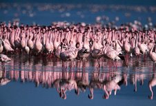
9.Lake Victoria, Uganda
While the communities living around the lake have many stories to tell in addition to the lake being a source of living for them, no need to add to what Wikipedia says;
"Lake Victoria or Victoria Nyanza (also known as Ukerewe and Nalubaale) is one of the Great Lakes of Africa. Lake victoria is 3rd biggest lake in the world covering 68,800 square kilometres (26,560 mi²) in size – making it the continent's largest lake, the largest tropical lake in the world, and the second largest fresh water lake in the world in terms of surface area (third largest if one considers Lake Michigan-Huron as a single lake). Being relatively shallow for its size, with a maximum depth of 84 m (276 ft) and a mean depth of 40 m (131 ft), Lake Victoria ranks as the seventh largest freshwater lake by volume, containing 2,750 cubic kilometres (2.2 million acre-feet) of water. It is the source of the longest branch of the NileRiver, the White Nile, and has a water catchment area of 184,000 square kilometres (71,040 mi²). It is a biological hotspot with great biodiversity. The lake lies within an elevated plateau in the western part of Africa's Great Rift Valley and is subject to territorial administration by Tanzania, Uganda and Kenya. The lake has a shoreline of 3,440 km (2138 miles), and has more than 3,000 islands, many of which are inhabited. These include the SseseIslands in Uganda, a large group of islands in the northwest of the Lake that are becoming a popular destination for tourists"
10.The people of Uganda the cultural diversity
The Uganda culture is made up of a dissimilar array of cultural groups.Itincludes a number of religious groups like Christians, Sikhs and Hindus. People speak in 40 languages out of which Luganda is the most common. Swahili is also used while English is the official language. Literature of Uganda is very rich as well.Many of the regions like Buganda, Bunyoro and Toro had kingdoms of their own. Lake Kyoga forms the northern periphery for the Bantu-speaking peoples, who dominate much of east, central and southern Africa. In Uganda they include the Baganda and several other tribes. In the north live the Lango and the Acholi, who speak Nilotic languages. Iteso and Karamojong who speak a Nilotic language, occupy the east parts of Uganda and few Pygmies live isolated in the rainforests of western Uganda. Each of the tribe is very respectful to their tradition and the culture of Uganda can be best described as a melting pot of diverse cultural practices. The Uganda people are quite hospitable.